Project Title: EO for Forest Fires Hotspot Detection
Funding body: Singapore National Environmental Agency
Main Objective: The objective of this project is to demonstrate the capability of combined Satellite data (optical and SAR) to help in the detection hotspots for forest fires and scar with better results than the current SPOT 4 or 5 alternatives.
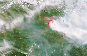
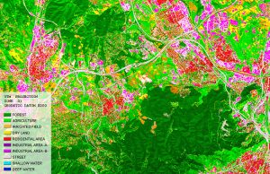
Project description: For several years the number of fires in Indonesian forests has increased. A new category of forest fire risk has appeared in some regions such as West Sumatra and Kalimantan. The fires affected a large portion of the Indonesian population causing economic hardship and disruption to commerce and short and long term health problems. The smoke and haze generated by the fires also caused disruptions and economic loss to many neighbouring countries such as Malaysia and Singapore causing diplomatic tensions. Optical satellite data, such as Spot 4 or 5 data, have been widely used to detect fire forest hotspot. However, the typical processing for Normalized Burn Ratio (NBR) from Spot 4 or 5 doesn’t see well through the smoke and this can have an effect on the clarity of the result. This is better solved in Sentinel 2 and Landsat-8, due to the fact of thermal band and the computation of the Normalized Burn Ration Thermal index (NBTR1).
On the other hand, the SAR (Synthetic Aperture Radar) data, by nature, can see through certain type of clouds and smoke. SAR is not able to actually “see” the hotspot, since it is not sensible to temperature change, nevertheless, it can potentially detect recently burned areas and the fire scar. By fusing both sources of information we have been able to demonstrate in this project that it is possible to estimate with a high likelihood the area boundaries of the fires and its scar.
The project is submitted jointly by Singapore National Environmental Agency and Starlab – Spain