Project Title: Monitoring urban sprawl and environmental considerations around Barcelona’s metropolitan area with the aid of satellite imagery. SPOT-5 Application Validation Programme (SAVP).
Funding body: Centre Nacional d’Etudes Spatiales (CNES) and Spot Image.
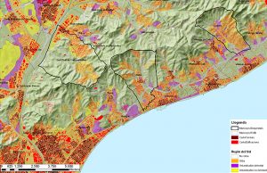
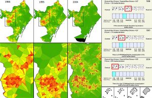
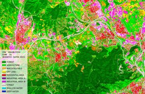
Project description: This project approaches the measurement of metropolitan urban growth from a strictly morphological perspective, drawing upon SPOT satellite imagery dating from 1995 and 2003, in order to quantify and analyse the process of ‘periurbanisation’ which has been experienced in Barcelona over this period. The principal objectives of this project are:
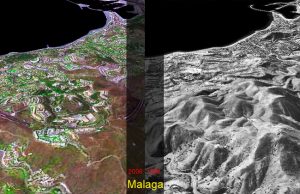
- Assess the increased accuracy afforded by the new generation of satellite images from SPOT5, for the monitoring of key urban development issues both within the confines and beyond the edge of the Barcelona’s metropolitan area- MAB.
- Explore which the SPOT5 images can aid in the quantification and analysis of the phenomenon of ‘periurbanisation’ and be able to assist in the differentiation of different land uses, both involving built form and in the absence thereof, particularly within the periphery of MAB and on the urban rural fringes of the individual towns and villages comprising the MAB.
The project carried out an evaluation of the operational application of the data sets deriving from SPOT5 satellite images in and around Barcelona for the CNES, as part of the SPOT Application and Validation Programme, is submitted jointly by the Universitat Politècnica de Catalunya (UPC) through its Centre de Política de Sòl I Valoracions (CPSV) and the Mancomunitat de Municipis de l’Àrea Metropolitana de Barcelona (MMAMB) through its Territorial Information and Technical Co-ordination Services Department.