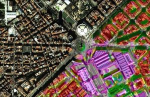
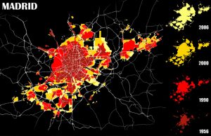
Applications: Town planning and management, Environmental modeling, Disaster management, Change detection and virtual reality
Benefits: Accurate cartographic feature extraction, Map updating, Clear visual results, Detailed information, Quick decision making
USERS: Private and Public Agencies, City planners, Territory and Sustainability Departments, Protection Authorities
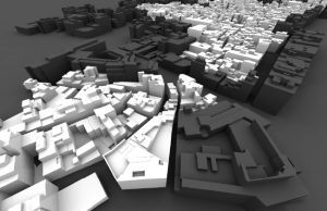
New three dimensional city views enhance any technical analysis experience when these images are closer to reality letting the experts to take finer decisions.
Visibird creates a 3D interactive tool for city planning and design derived from high resolution aerial photography, satellite images and a database containing all the necessary information of the city. This intelligent 3D geospatial mapping contains all the necessary information about the city. This allows the development of an interactive 3D representation, improving visual techniques used by city planner and municipal managers. A number of spatial structures are simulated in relation to the collected data even extreme factors like monitoring the movement of air pollutants over the land could be considered. In this way, all possible environmental issues are object to study, even the ecological planning is considered to meet the requirements of future designs.