Applications: Town planning and management, Land use classification & analysis, Urban change detection, Property and Facilities Management
Benefits: Rapid data collection, Reduced Field work & Visual interpretation, Clear visual results, Detailed information
USERS: Private and Public Agencies, City planners, Territory and Sustainability Departments, Protection Authorities
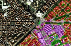
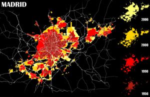
High resolution Aerial photography and satellite images together with a GIS are playing an increasingly important role in the management of our territory and being able to follow and monitor the slightest change taking place; such as, new roads, new buildings, etc. They are becoming valuable instruments for urban planning and future expansion of the cities. The main objective of these tools is to have a constant knowledge of the status of a territory by being able to update the technical cartography with great detail to effectively manage the territory.
Visibird is a specialist in the creation of high quality digital imagery products and customize the required applications for the customer by investing in the latest technology. We offer graphical interface built to see changes in the territory over time, to encourage sustainable development. The construction of this database will help in centralizing all the information making it interactive with a GIS. As well as the database could then be updated constantly and together with high resolution images in order to make the work flow easier and more effective.