Applications: Urban Ecosystem analysis, Land Cover trend analysis, Natural resource management, Land Use Change analysis, Hydrometeorological models
Benefits: National and International monitoring, Ability to monitor change, Detailed information, Rapid detection and response
USERS: Private and Public Agencies, City planners, Territory and Sustainability Departments, Protection Authorities
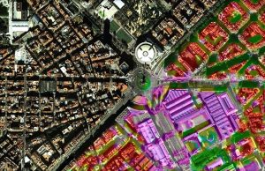
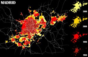
Aerial photography and Satellite images provide a valuable tool for land monitoring, being able to detect any change over time. This information could be used to manage and plan future activities in a sustainable way. Land use cover maps provide real information of the status of the territory and could be updated continuously.
Visibird is able to offer a service to analyze any aerial photo, satellite image and provide intelligent thematic maps of different covers or uses types compatible with GIS software. The combination of using time series of data (up-to-date) provides a powerful tool in the analysis of land use change over time, giving a detailed perspective on the history of change in an area.
Map information is obtained by comparing a series of images at medium and high resolution of specific areas. Being able to determine types of use & cover (e.g. NDVI, urban areas, etc.) and detect any change over time by overlapping images and running change detection algorithms. The different types of land uses are determined by special classification treatment processes and visual interpretation. In-situ data could also be compared to the different types of spectral signatures of remote sensed data.