Applications: Forest Management, Hotspot detection, Ignition probability index, Firemen operations, Delimitation of burned areas
Benefits: Fires and weather historical record, Tracks firefighting resources, Reduced fire risks, Ability to monitor the change
USERS: Private and Public Agencies, Environment and Houses Departments, Firemen, Local Governments, Regional offices of the Corps of rural agents.
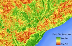
By using high and medium resolution aerial photography and satellite images together with GIS allow us to create an index of vegetation structure and its biodiversity, water stress, land use dynamics, landscape conservation to be combined as well with climate data for the elaboration of a fire risk index map.
Visibird helps to develop a management tools system to prevent and deal with forest fires as well as calculate burned areas to quantify the costs of the affected areas. So, It’s a valuable tool for the conservation of the forest ecology and civil protection.