Applications: Measure geographical risks, Emergency management, Prevention and Evacuation planning, Human search and rescues, Team rescue operations
Benefits: Planning safer communities, Map updating, Clear visual of risk and safety data, Quick evaluation of magnitude disasters
USERS: Private and Public Agencies, Civil Protection, Geological survey, Territory and Sustainability Departments, Airports and Port Authorities
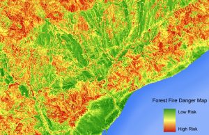
Earth observation is one of the pillars of the disaster risk management practice in the World. The risk of natural disasters can be reduced by understanding our environment. Our main objective is to provide vital information through Earth-observing sensing data and GIS analysis to prepare and advise high risk areas ; such as: seismic, flooding, volcanic, industrial, etc.
Visibird provides valuable tools to manage these high risk areas to prevent emergencies and updating maps at different scales in order to analyze and monitor risk factors and be prevent natural disasters, such as:
- Land subsidence and Interferometry maps.
- Geomorphological and geolithological maps.
- Hydrographical and hydrogeological maps.
- Flooding maps.
These maps could be used as complementary data in case of natural disasters or emergencies.